The Barbara Lyn was originally lost on October 1st, 1990 about 12 miles north of Pte. Aux Barges in a storm. The tug sunk in about 208 feet of water. In 2014, a salvage attempt was made on the tug and the tug was successfully raised to the surface. However, once brought to the surface the tug was grounded off of Port Austin as a storm and bad weather moved in. The subsequent storm destroyed the pilothouse and re-sunk the tug in 20 ft of water.
Photogrammetry model of the Barbara Lyn as it sits on the bottom of Lake Huron.
An example of a typical Mackinaw design boat. (Photo Credit: Robert McGreevy)
Michigan
Divers, LLC announces the discovery of a previously unknown shipwreck, near the
Grindstone City Harbor. Captain Cindy Lynch, her husband
Captain Mike Lynch and Kevin Jimkoski were scuba diving from shore and
discovered the wreck site. It was initially believed that the wreckage
was from the Tug Margaretta, which exploded outside of the Grindstone Harbor in
1907. On a recent dive, Cindy, Chris Roth, and Kevin further explored the
site and it was determined that the wreckage was not from a tugboat but from a
small, single-masted sailing vessel. After consulting with local
historian and marine artist, Robert McGreevy, it was determined that the
wreckage was likely from a “Mackinaw Boat,” which was common for the area,
around the end of the 19th century. The small sailing vessel
was of “double-end design” and had at least one mast, a drop centerboard, and
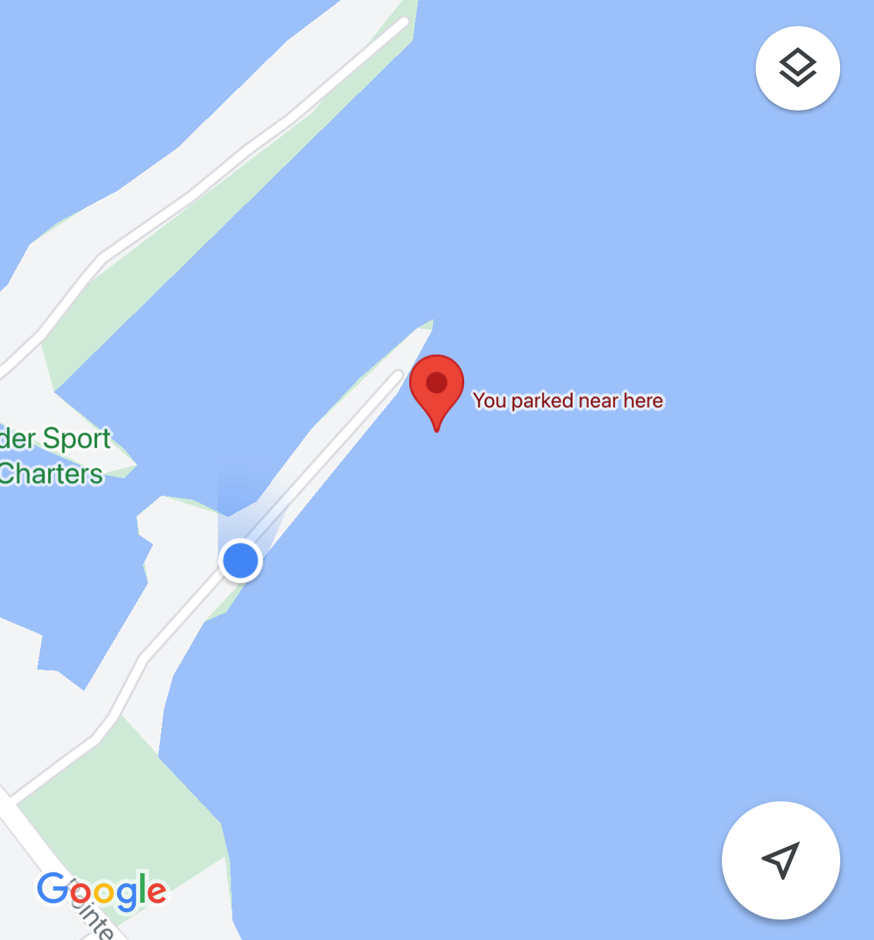
a tiller. The wreck site lies within the boundaries of the Thumb Bottom
Land Preserve and can be found in 8 ft of water, approximately 150’ due east of
the end of Grindstone City short point. People exploring the site can
expect to find many small artifacts and several different fish species.
This site should be an excellent local attraction for beginning divers, snorkelers,
and kayakers.
Location of the Mackinaw design wreck site. Located just east (about 200-250ft) off the end of the short point at the Grindstone City marina.
Photogrammetry model of the wreck site.
Divers Cindy Lynch and Kevin Jimkoski pose at the bow of the wreck site.
Remains of the bow. Notice the metal skeg on the keel.
Another view of the bow remains.
Remains of the stern.
Photomosaic of the keel showing the location of the drop centerboard.
The drop centerboard sits on the ribs at the port side near the bow.
JACOB BERTSCHY - 10 Feet Deep. The Jacob Bertschy was lost in a storm on September 3rd, 1879. It grounded with 51 crew and passengers (everyone was saved) and a cargo of shingles and wheat. The Bertschy was a wooden steamer built in 1867 in Sheboygan, WI, and was 138 feet long.
Drawing of the Jacob Bertschy by Artist Robert McGreevy (www.McGreevy.com)
Today the Bertschy sits in only 6-8 feet of water and is a possible shore dive (very long swim) out of Grindstone City Harbor or is reachable by boat for snorkeling or scuba diving.
News articles regarding the loss of the Jacob Bertschy
June 2021
There seems to be very little available or published in terms of a photo of the Jacob Bertschy or images of the wreckage. Capt'n Cindy decided it was time to change at least the lack of underwater images of the Jacob Bertschy wreck site. Initially, the wreck site of the Jacob Bertschy was listed as a shore dive from the Grindstone Marina. As we investigated the location of the wreck site, it was determined that it would be a long swim from shore to the reported location. Cindy rightfully opted to perform the search with her DiveX Pirahna DPV (Dive Propulsion Vehicle) or commonly called dive scooter.
Capt'n Cindy with her DiveX Pirahna DPV
Scootering out toward the believed wreck location, Cindy was able to find scattered remains of the vessel indicating she was headed in the right direction.
'
Scattered pieces of wreckage from the Jacob Bertschy
Continuing the search, additional pieces were found.
Additional wreckage scattered on the lake floor of the Jacob Bertschy
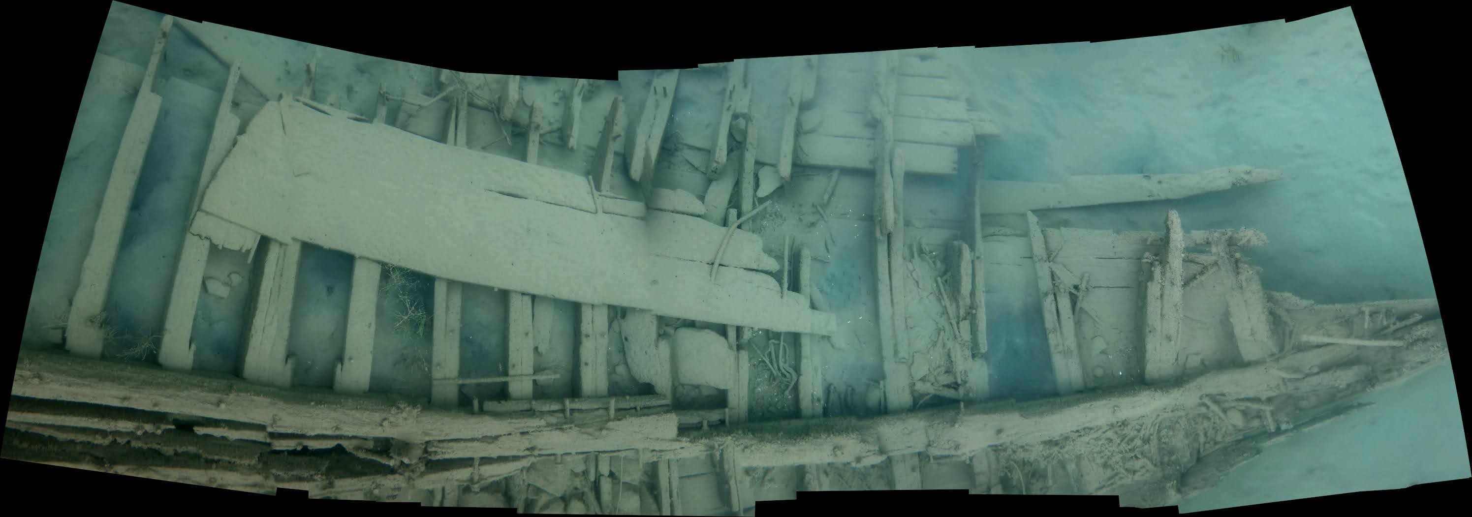
Finally, after additional searching of the area with the DVP, Cindy found the largest piece of the Jacob Bertschy wreckage, the keel. A photogrammetry model was created from the footage gathered to better understand how the wrecksite looks today.
Photogrammetry model of the wreck site of the Jacob Bertschy as it lies on the bottom of Lake Huron.
After many years on the bottom of Lake Huron, the wind, waves, and have broken up the wreck and scattered the debris across a large bottomland area. Much of the keel is now buried in the rock and gravel and the wreckage sits embedded and even with the bottom contours.
The Jacob Bertschy wreck site lies within theThumb Area Bottomland Preserve. As mentioned previously this is probably a site best enjoyed from a boat. The swim from shore is rather long!